

No. 43 St. Saviour, Southwark Volunteer
£15.00
St. Saviour Parish, Southwark (scroll down for a more detailed Description)
The first reprints of the 1798 aquatints by Thomas Rowlandson (published by Rudolph Ackermann) published in 1972 by Hugh Evelyn Limited.
Image size is 20.5 x 25.5 cm [8” x 10”] against a light greyish orange background (c. RGB fcf2e1) impressed on medium high white matt cartridge paper of c. 120 g/m2.
Print size: c. 26.2 x 33.7 cm [17” x 12 ¾”] may vary slightly from printers’ cut 50 years ago
Details of London Wards and Parishes provided by © the British Library
We offer thanks to the Trustees of the British Library and British Museum and Wikipedia for some text (and map outlines
Print is STANDARD size – shipping is the same for 1 to 10 prints (based on largest print size in your order) – see Shipping & Returns
Who were the Loyal Volunteers ? See here
In stock
Description
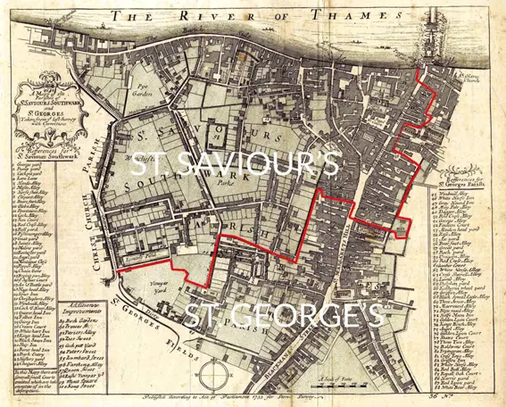
Southwark St Saviour (see map) was a civil parish in the metropolitan area of London, England, and part of the ancient Borough of Southwark. It was formed in 1541 from the union of the parishes of St Margaret and St Mary. It was abolished in 1930, however residents of the former parish receive a rebate against local taxation because of the presence of Borough Market. It included the Liberty of the Clink which was a special jurisdiction until 1889. The parish contained the large wholesale food market Borough Market. The trustees of the market have been appointed by the parish since 1756. Additionally, any profit from the operation of the market must be repaid to the local authority and used to offset local taxation. This arrangement has outlasted the abolition of the parish in 1930 and council tax payers in the former parish receive a rebate against their Council Tax. To the north the parish had a long boundary fronting the River Thames and the City of London. It stretched, in modern terms, to include the whole of the Bankside Power Station in the west and fell just short of London Bridge station in the east. Half of the current site of Guy’s Hospital was within the parish, with Great Maze Pond broadly marking the boundary with St Olave. Parts of what is now Newcomen Street, Little Dorrit Court and Southwark Bridge Road broadly marked the irregular southern boundary with St George the Martyr parish. In the west there was a boundary with Southwark Christchurch (formerly the liberty of Paris Garden) that followed, but fell short of, what is now Great Suffolk Street, Sumner Street, and Holland Street.
Additional information
| Weight | 0.0121 kg |
|---|---|
| Dimensions | 25 × 35 cm |


