

No. 44 St. Olave, Southwark Volunteer
£15.00
St. Olave’s Parish, Southwark (scroll down for a more detailed Description)
The first reprints of the 1798 aquatints by Thomas Rowlandson (published by Rudolph Ackermann) published in 1972 by Hugh Evelyn Limited.
Image size is 20.5 x 25.5 cm [8” x 10”] against a light greyish orange background (c. RGB fcf2e1) impressed on medium high white matt cartridge paper of c. 120 g/m2.
Print size: c. 26.2 x 33.7 cm [17” x 12 ¾”] may vary slightly from printers’ cut 50 years ago
Details of London Wards and Parishes provided by © the British Library
We offer thanks to the Trustees of the British Library and British Museum and Wikipedia for some text (and map outlines
Print is STANDARD size – shipping is the same for 1 to 10 prints (based on largest print size in your order) – see Shipping & Returns
Who were the Loyal Volunteers ? See here
In stock
Description
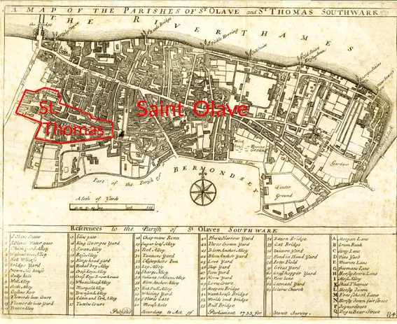
Southwark St Olave (see map) was an ancient civil and ecclesiastical parish on the south bank of the River Thames, covering the area around where Shard London Bridge now stands in the modern London Borough of Southwark. The boundaries varied over time but in general the parish stretched east from London Bridge past Tower Bridge to St Saviour’s Dock. Southwark St Olave and St Thomas replaced the civil parish in 1896. It was abolished in 1904 and absorbed by Bermondsey parish. Southwark St Olave formed part of the ancient Borough of Southwark. Part of its area was split off around 1550 to create Southwark St Thomas, corresponding to the hospital of the Archbishop of Canterbury. In 1733, part of area was used to create Southwark St John Horsleydown. The parish became, with St John Horsleydown and St Thomas, part of the St Olave Poor Law Union and in 1855 it became part of the St Olave District of the Metropolis. It was absorbed by the County of London in 1889.
In 1896 St Olave was abolished as a civil parish and was combined again with Southwark St Thomas to form Southwark St Olave and St Thomas. In 1900 the combined parish became part of the Metropolitan Borough of Bermondsey and was abolished in 1904, with its former area absorbed into the Bermondsey civil parish, as was that of St John Horsleydown.
The ecclesiastical parish of St Olave was abolished in 1947, and then formed part of Southwark St Olave and St John.
Additional information
| Weight | 0.0121 kg |
|---|---|
| Dimensions | 25 × 35 cm |


