

No. 7 St. Clement Danes Volunteer
£15.00
St. Clement Danes Parish (scroll down for a more detailed Description)
The first reprints of the 1798 aquatints by Thomas Rowlandson (published by Rudolph Ackermann) published in 1972 by Hugh Evelyn Limited.
Image size is 20.5 x 25.5 cm [8” x 10”] against a light greyish orange background (c. RGB fcf2e1) impressed on medium high white matt cartridge paper of c. 120 g/m2.
Print size: c. 26.2 x 33.7 cm [17” x 12 ¾”] may vary slightly from printers’ cut 50 years ago
Details of London Wards and Parishes provided by © the British Library
We offer thanks to the Trustees of the British Library and British Museum and Wikipedia for some text (and map outlines
Print is STANDARD size – shipping is the same for 1 to 10 prints (based on largest print size in your order) – see Shipping & Returns
Who were the Loyal Volunteers ? See here
In stock
Description
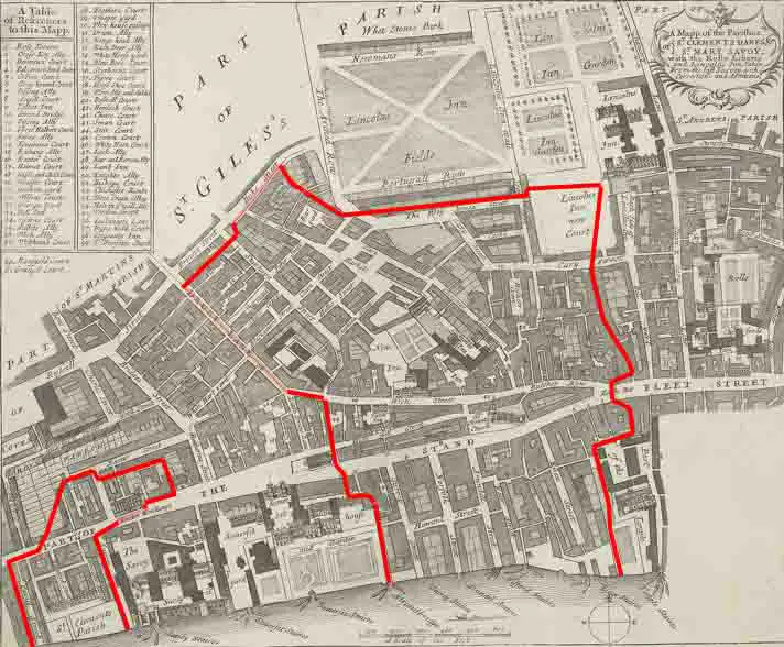
St Clement Danes (see map) was a civil parish in the metropolitan area of London, England; an ecclesiastical version remains (see its Anglican church, St Clement Danes). The parish was split between the Liberty of Westminster and the Liberty of the Duchy of Lancaster (also known as of the Savoy). The area is colloquially split between Aldwych and Adelphi areas associated with the larger Strand area in the extreme east of the City of Westminster. It includes hotels, restaurants, the Indian and Australian High Commissions and the London School of Economics. To its west is Charing Cross station which faces Trafalgar Square. It took its name from the dedication of the church of St Clement Danes. It is recorded in the early 12th century as parochia Sancti Clementis ecclesie Dacorum or ‘the parish of St Clement’s church of the Danes’. The name suggests there were Danes living in the area, to the west of the City of London. The parish consisted of two areas extending into the left (north) half of the Thames. The main part formed the east part of Westminster vill which was largely gardens and rural until the late medieval period. It adjoined the Liberty of the Rolls and the Temple area of the City of London. To the west it had a straight boundary with two parishes of contrasting size: St Martin in the Fields (large) and St Mary le Strand (very small). To the north it was bounded by St Giles in the Fields. The western detached part was very small; it lay between an arm of St Martin in the Fields by the river and the few-acres Precinct of the Savoy of similar size to St Mary le Strand also by the river.
Additional information
| Weight | 0.0121 kg |
|---|---|
| Dimensions | 25 × 35 cm |


