

No. 45 Poplar & Blackwall Volunteer
£15.00
Poplar and Blackwall (scroll down for a more detailed Description)
The first reprints of the 1798 aquatints by Thomas Rowlandson (published by Rudolph Ackermann) published in 1972 by Hugh Evelyn Limited.
Image size is 20.5 x 25.5 cm [8” x 10”] against a light greyish orange background (c. RGB fcf2e1) impressed on medium high white matt cartridge paper of c. 120 g/m2.
Print size: c. 26.2 x 33.7 cm [17” x 12 ¾”] may vary slightly from printers’ cut 50 years ago
Details of London Wards and Parishes provided by © the British Library
We offer thanks to the Trustees of the British Library and British Museum and Wikipedia for some text (and map outlines
Print is STANDARD size – shipping is the same for 1 to 10 prints (based on largest print size in your order) – see Shipping & Returns
Who were the Loyal Volunteers ? See here
In stock
Description
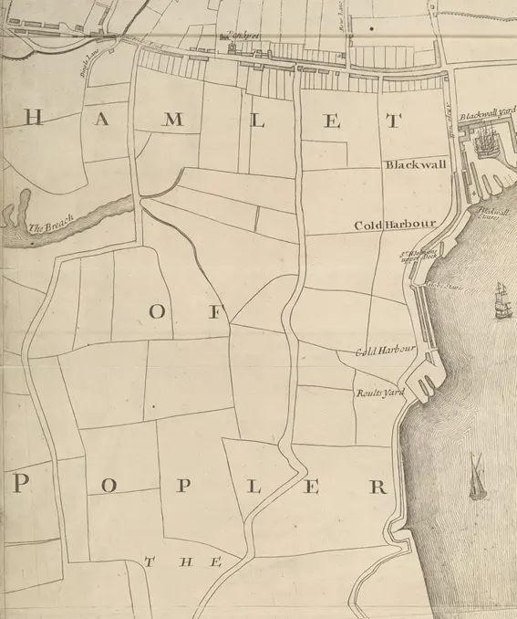
Poplar is a district in East London, England, the administrative centre of the borough of Tower Hamlets. (See 1703 map of Poplar and Blackwall). Five miles (8 km) east of Charing Cross, it is part of the East End. It is identified as a major district centre in the London Plan, with its district centre being Chrisp Street Market, a significant commercial and retail centre surrounded by extensive residential development. Poplar includes Poplar Baths, Blackwall Yard and Trinity Buoy Wharf and the locality of Blackwall.
Originally part of the Manor and Ancient Parish of Stepney, the Hamlet of Poplar had become an autonomous area of Stepney by the 17th century, and an independent parish in 1817. The Hamlet and Parish of Poplar included Blackwall and the Isle of Dogs. After a series of mergers, Poplar became part of the London Borough of Tower Hamlets in 1965. Blackwall is an area of Poplar in the London Borough of Tower Hamlets, East London. The neighbourhood includes Leamouth and the Coldharbourconservation area. The area takes its name from a historic stretch of riverside wall built along an outside curve of the Thames, to protect the area from flooding. While mostly residential, the Poplar Dock and Blackwall Basin provide moorings for vessels. Blackwall Yard became a major sea hub, and the district was a significant part of the Port of London, and involved with important voyages for over 400 years. Shipfitting and repair was taking place by 1485 and shipbuilding would take place in the area later too. In 1576, Martin Frobisher left Blackwall and landed at Frobisher Bay on Baffin Island, claiming it for England (its first overseas possession) in the name of Queen Elizabeth I. Frobisher was funded by the Muscovy Company seeking the North West Passage. In the early years of the 17th century the port was the main departure point of the English colonisation of North America and the West Indies launched by the London Company. On 20 December 1606, three ships, Susan Constant, Godspeed and Discovery, sailed from Blackwall, landing in Virginia on 26 April 1607 to establish the first permanent English settlement, Jamestown. The East and West India Docks were constructed at the beginning of the 19th century.
Additional information
| Weight | 0.0121 kg |
|---|---|
| Dimensions | 25 × 35 cm |


