

No. 15 Bethnal Green Volunteer Light Infantry
£15.00
Bethnal Green in 1770 (scroll down for a more detailed Description)
The first reprints of the 1798 aquatints by Thomas Rowlandson (published by Rudolph Ackermann) published in 1972 by Hugh Evelyn Limited.
Image size is 20.5 x 25.5 cm [8” x 10”] against a light greyish orange background (c. RGB fcf2e1) impressed on medium high white matt cartridge paper of c. 120 g/m2.
Print size: c. 26.2 x 33.7 cm [17” x 12 ¾”] may vary slightly from printers’ cut 50 years ago
Details of London Wards and Parishes provided by © the British Library
We offer thanks to the Trustees of the British Library and British Museum and Wikipedia for some text (and map outlines
Print is STANDARD size – shipping is the same for 1 to 10 prints (based on largest print size in your order) – see Shipping & Returns
Who were the Loyal Volunteers ? See here
In stock
Description
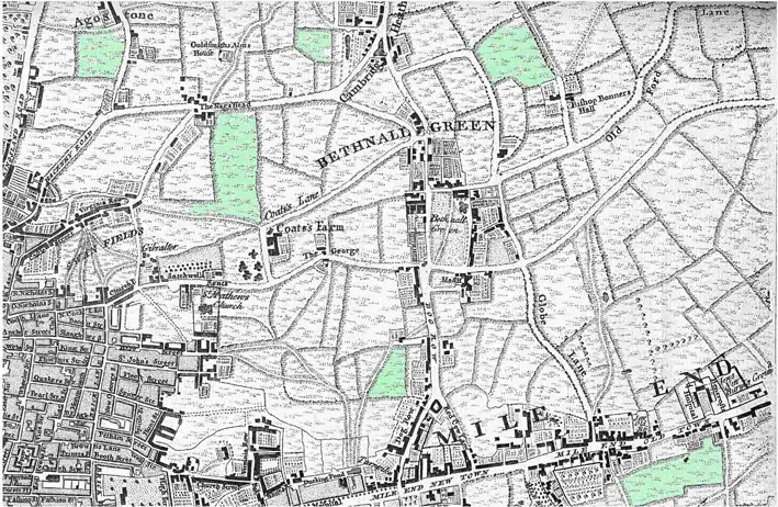
Bethnal Green (see old map) is an area in the East End of London 3 miles (4.8 km) northeast of Charing Cross. The area emerged from the small settlement which developed around the Green, much of which survives today as Bethnal Green Gardens, beside Cambridge Heath Road. By the 16th century the term applied to a wider rural area, the Hamlet of Bethnal Green, which subsequently became a Parish, then a Metropolitan Borough before merging with neighbouring areas to become the north-western part of the new London Borough of Tower Hamlets. Economic focus shifted from mainstream farming produce for the City of London – through highly perishable goods production (market gardening), weaving, dock and building work and light industry – to a high proportion of commuters to city businesses, public sector/care sector roles, construction, courier businesses and home-working digital and creative industries. Identifiable slums in the maps of Booth in Life and Labour of the People in London (3 editions, 1889–1903) were in large part cleared before the aerial bombardment of the Second World War which accelerated clearance of many tightly packed terraces of small houses to be replaced with green spaces and higher-rise social housing. The term Bethnal Green originally referred to a small common in the Manor and Ancient Parish of Stepney; around which a small settlement developed. By the seventeenth century the area had become a Hamlet, a territorial sub-division of Stepney, with a degree of independence. Continued housebuilding and population growth in the 18th century led to the Hamlet area becoming a fully independent daughter parish in 1743. The parish had a church, a benefice (for its priest) and vestry (for its people) in 1743. In 1855 Bethnal Green was included within the area of the Metropolitan Board of Works to which it nominated one member and the various local government bodies were replaced by a single incorporated vestry which consisted of 48 elected vestrymen.
Additional information
| Weight | 0.0121 kg |
|---|---|
| Dimensions | 25 × 35 cm |


