

No. 10 St. Martin’s in the Fields Volunteer
£15.00
St. Martin-in-the-Fields Parish (scroll down for a more detailed Description)
The first reprints of the 1798 aquatints by Thomas Rowlandson (published by Rudolph Ackermann) published in 1972 by Hugh Evelyn Limited.
Image size is 20.5 x 25.5 cm [8” x 10”] against a light greyish orange background (c. RGB fcf2e1) impressed on medium high white matt cartridge paper of c. 120 g/m2.
Print size: c. 26.2 x 33.7 cm [17” x 12 ¾”] may vary slightly from printers’ cut 50 years ago
Details of London Wards and Parishes provided by © the British Library
We offer thanks to the Trustees of the British Library and British Museum and Wikipedia for some text (and map outlines
Print is STANDARD size – shipping is the same for 1 to 10 prints (based on largest print size in your order) – see Shipping & Returns
Who were the Loyal Volunteers ? See here
In stock
Description
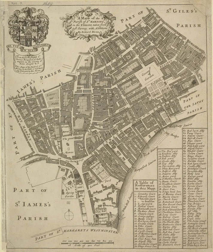
St Martin-in-the-Fields is a Church of England parish church at the north-east corner of Trafalgar Square in the City of Westminster, London. It is dedicated to Saint Martin of Tours. There has been a church on the site since at least the medieval period. It was at that time located in the farmlands and fields beyond the London wall, when it was awarded to Westminster Abbey for oversight. It became a principal parish church west of the old City in the early modern period as Westminster’s population grew. When its medieval and Jacobean structure was found to be near failure, the present building was constructed in an influential neoclassical design by James Gibbs in 1722–1726. The church is one of the visual anchors adding to the open-urban space around Trafalgar Square. St Martin-in-the-Fields (see map) was a civil parish in the metropolitan area of London, England. It took its name from the church of St Martin-in-the-Fields and was within the Liberty of Westminster. It included within its boundaries the former extra-parochial areas of Buckingham Palace and St James’s Palace. It was an ancient parish. In 1542 it gained most of what became its final form “lands between the church of St Clement Danes and the Palace of Westminster” from the parish of Westminster St Margaret. It originally included four other areas, carved out as new parishes. It originally amounted to the area in green on the map, the whole Liberty, except for the part of St Margarets which formed Knightsbridge (the far west) and the part of St Clement Danes and St Mary le Strand within the ancient Liberty, very small areas north of the Strand (in the Liberty’s extreme east).
Additional information
| Weight | 0.0121 kg |
|---|---|
| Dimensions | 25 × 35 cm |


